| The Plan of Chicago |
| Chicago in 1909 |
| Planning Before the Plan |
| Antecedents and Inspirations |
| The City the Planners Saw |
| The Plan of Chicago |
| The Plan Comes Together |
| Creating the Plan |
| Reading the Plan |
| A Living Document |
| Promotion |
| Implementation |
| Heritage |

|
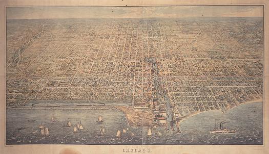
This large and magnificent lithograph of Chicago in 1857 by Christian Inger is based on a drawing by I. T. Palmatary and was published by Braunhold & Sonne. Its detail is astonishing, and includes the haymarket that once stood in the middle of Randolph Street west of the Chicago River (and gave the area the name Haymarket Square); the 1853 Courthouse (the name for the city hall) bordered by LaSalle, Randolph, Clark, and Washington Streets; the warehouses and heavy traffic along the Chicago River; and, near each other on the North Side, both the first Holy Name Cathedral and St. James Episcopal Church (the former completely destroyed by the fire and replaced on the same site, the latter severely damaged and rebuilt). Of particular interest in terms of future planning is the absence of what would become Grant Park. The Illinois Central Railroad (note the locomotive speeding along the trestle the company constructed as a breakwater in exchange for obtaining this route) and its facilities instead dominate the downtown lakefront. |
||
|
The Electronic Encyclopedia of Chicago © 2005 Chicago Historical Society.
The Encyclopedia of Chicago © 2004 The Newberry Library. All Rights Reserved. Portions are copyrighted by other institutions and individuals. Additional information on copyright and permissions. |
||