|
Gallery
|
| The Grid |
| Origins of the Grid |
| The River Breaks the Grid |
| Rationalization of Streets |
| Embracing / Rejecting the Grid |
| Transportation and the Grid |
Aerial view of 79th and Western (Hinkamp & Co.'s Western Avenue subdivision), 1926
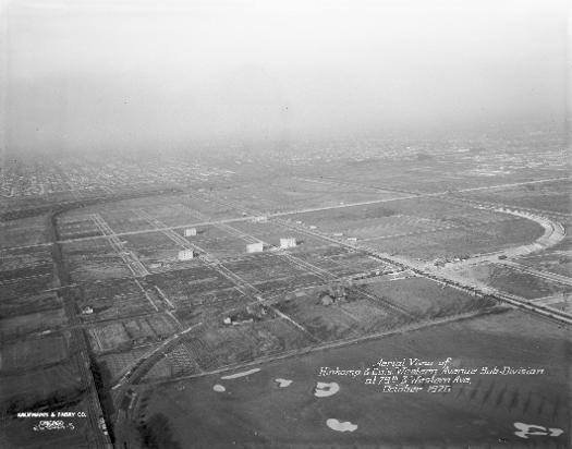
Few images show the city's grid more clearly than this one does, with the empty checkerboard of streets in the foreground sprinkled with a few two-flats.
See also: Ashburn; Housing Types; Streets and Highways; Subdivisions
Chicago Plan Commission Subdivision Diagram, 1943
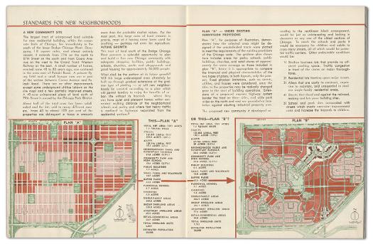
The Chicago Plan Commission published a booklet in June 1943 entitled "Building New Neighborhoods," which proposed redevelopment of "blighted and near-blighted" areas within the city and suggested that residents "want more than just buildings crowded together on narrow lots, facing long straight streets." One of their proposed redevelopments was for the area bounded by 77th Street, Cicero Avenue, 87th Street, and Grand Trunk Western Railroad. Their recommended Plan B included curvilinear streets and cul-de-sacs and eliminated "costly to construct, expensive to maintain" alleys.
See also: Planning Chicago; Planning, City and Regional; Subdivisions
Aerial view of southwest Chicago, 1955
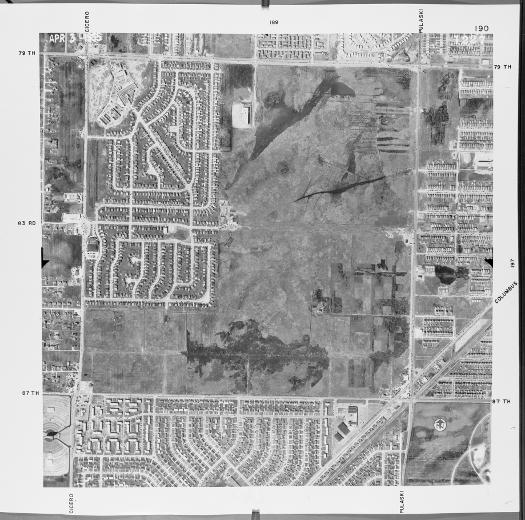
The photograph taken in 1955 of a square-mile section of Chicago (Cicero Avenue on the west, Pulaski Street on the east, 79th Street on the north, and 87th Street on the south) shows the beginnings of development. A curvilinear layout empties into Scottsdale Shopping Center, still under construction at the time. A Tribune article from May 18, 1953, announced that the future shopping center would "be an integral part" of the Raymond T. Lutgert Construction Company's 120-acre development.
See also: Ashburn; Metropolitan Growth; Shopping Districts and Malls; Subdivisions
Aerial view of southwest Chicago, 1962
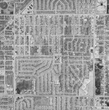
By 1962, most of the area had filled in. The remainder of the upper portion of the area is filled with curvilinear streets, although the streets are closer together and the lot sizes smaller. The remainder of this square mile has Chicago's traditionally straight streets. Visible landmarks include Bogan High School and Bogan Park at the southeast corner of 79th and Pulaski Streets and a portion of St. Mary's Cemetery at the southeast corner of 87th and Pulaski Streets. The undeveloped areas at the southwest corner of 79th and Pulaski Streets and the large open area at the northeast corner of Cicero Avenue and 87th Street have filled in since 1962 with grid-style development.
See also: Ashburn; Cemeteries; Metropolitan Growth; Streets and Highways
|
The Electronic Encyclopedia of Chicago © 2005 Chicago Historical Society.
The Encyclopedia of Chicago © 2004 The Newberry Library. All Rights Reserved. Portions are copyrighted by other institutions and individuals. Additional information on copyright and permissions. |