| Entries |
| W |
|
Water
|
|
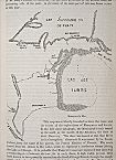
Before its natural topography was altered, the Chicago River reached the Des Plaines River during the wet seasons via a shallow lake across the divide between the Great Lakes and Mississippi River drainage systems. The first regional public work proposed was a canal crossing the Chicago portage, to create a permanent, navigable waterway between the Atlantic Ocean and the Gulf of Mexico. When completed in 1848, the Illinois & Michigan Canal was fed by the Des Plaines and Calumet Rivers and by the South Branch of the Chicago River through a lift wheel at Bridgeport.
A second topographical feature that contributed to the shaping of Chicago's wastewater strategy was that, during wet seasons, the flat, nonporous terrain turned to mud. In 1852, the Illinois legislature empowered sewage commissioners to install sewers in the most densely settled areas of Chicago.
|
The river was probably first reversed during several dry summers in the 1850s. To maintain the summit level in the canal, the Bridgeport lift wheel was run continuously, and lake water was pulled through the river. By 1860 Chicago's sewerage commissioners were considering a permanent reversal.
|
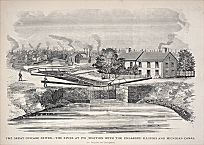
The Sanitary District Enabling Act of May 29, 1889, was a direct result of the Drainage and Water Supply Commission's recommendation to create a regional government for solving water supply and wastewater problems. The enabling act provided for the construction of the Chicago Sanitary and Ship Canal to collect sewage and discharge it, diluted with Lake Michigan water, into the Des Plaines River. It was cheaper to build a new canal than enlarge the old one. Section 23 set the channel's capacity at 10,000 cubic feet per second, the Chicago River's maximum measured flood flow. Over time, the district annexed contiguous areas. The two largest additions, the North Shore and Calumet areas, were added in 1903. The North Shore (1910) and the Calumet-Sag (1922) Channels were constructed to serve these areas.
In 1895 a federal commission investigated the new channel's potential effect on lake and harbor levels. Its report claimed that the district's proposed diversion of 10,000 cfs would lower the level of the Great Lakes by six inches. From this point forward, overestimates would fuel the long-running “lake levels controversy.”
The concern with lake levels, which was more likely the result of climatic variation than Chicago's diversion, was undoubtedly influenced by the fact that several Great Lakes states brought lawsuits to restrain Chicago from diverting any water at all. The inclusion of Canada in these suits, through the International Waterways Commission, gave impetus to the effort. The IWC argued that the growth of industry, combined with continued population growth, would put significant pressure on the sewage-handling capabilities of the channel system. All the critics, as well as many within the district, agreed that some form of sewage treatment would eventually prove necessary in addition to (if not in place of ) the open sewers.

|
Residents of the Illinois River basin, into which the main channel emptied, objected to receiving Chicago's wastewater. St. Louis believed the wastewater posed a threat to its Mississippi River water supply. On January 2, 1900, the district quietly removed the dam at the main channel's northern end, and two weeks later, on January 17, the dam at Lockport opened. That same day, Missouri petitioned the U.S. Supreme Court to enjoin the state of Illinois and the Sanitary District of Chicago from discharging sewage into the new canal, a suit that was ultimately unsuccessful.

|
Three important problems persist. First, the lake levels controversy remains. Since the channel system still receives the treated effluent and overflow, it is necessary for some diversion to provide a current. When drought conditions in the 1980s hampered navigation on the Illinois and Mississippi Rivers, suggestions that the Chicago diversion be increased were opposed on the basis of the potential reduction in lake levels.
Second, pollution continues to affect the area. In 1969, the Sanitary District adopted an ordinance that forced pretreatment of industrial pollutants at their source. It prohibited discharges into Lake Michigan and reduced those into the waterways. Although more than 90 percent of the district's wastewater is treated, a heavy rainfall or quickly melting snow still can force the district to open the floodgates and let raw sewage escape into the lake, violating the spirit, if not the letter, of this law.

|
From the initial reversal of the river, to the creation of the Sanitary District, to the planning mandated by federal law, as the city's human and business populations grew, the underlying objective of Chicago's wastewater strategy has been to protect and conserve the area's Lake Michigan water supply.
The Encyclopedia of Chicago © 2004 The Newberry Library. All Rights Reserved. Portions are copyrighted by other institutions and individuals. Additional information on copyright and permissions.