| Entries |
| O |
|
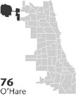
O'Hare
|
 Community Area 76, 14 miles NW of the Loop. The land constituting the O'Hare Community Area was only thinly developed before
World War II.
The 1829
Treaty
of Prairie du Chien gave two square miles around the
Des Plaines River
to Alexander Robinson, a
Scottish
-
Ottawa
interpreter who had aided whites escaping the
Fort Dearborn
Massacre. In the early 1840s, a few families settled along what would become Higgins Road, while immigrants from
Germany
settled in the southwest section of the area, establishing a church and St. Johannes
Cemetery
in 1849. The northeastern section was an unincorporated area called Orchard Place, named for the depot the Wisconsin Central
Railroad
opened there in 1887. Despite the railroad, however, few people settled in Orchard Place. A residential
subdivision
opened in the 1930s, but all traces of it vanished with the developments of World War II.
In 1942, Douglas Aircraft took over Orchard Place for the production of cargo planes. After war production ended, the facility became a commercial airport, and in 1947 the Chicago City Council picked it as the site for the city's new international airport (named for aviator Edward H. “Butch” O'Hare). All local facilities, except for St. Johannes Cemetery, were removed.
In order to consolidate its control over the airport area, Chicago annexed it in March 1956, including the western edge, in DuPage County. Because legal incorporation required that annexed areas be contiguous with Chicago, the city council also annexed a narrow stretch of Higgins Road to connect the main body of the city with the airport. Concerned that this tie was too tenuous, Chicago overrode the objections of surrounding suburbs like Schiller Park, annexing the forest preserve areas named for Alexander Robinson and his wife in 1958 and exchanging Higgins Road for a wider stretch along Foster Avenue in 1961. The building of the Kennedy Expressway in the late 1950s further reinforced the link between air travelers and the Loop. The addition of such a large amount of land necessitated the creation of a new community area on the city's planning map, setting a precedent for the secession of Edgewater from Uptown.
The rapid success of the airport inspired a tremendous increase in nearby land values. Along the expressway, developers built a gleaming row of office towers occupied by businesses taking advantage of the proximity to other cities provided by the airport. High-rise apartment buildings and a few small tracts of single-family houses and condominiums made the portion of O'Hare bisected by Norridge a residential area in the 1960s. Employees of the airport and its airlines occupied many of these homes.
| O'Hare (CA 76) | |||||
| Year |
Total
(and by category) |
Foreign Born | Native with foreign parentage | Males per 100 females | |
| 1960 | 763 | — | — | ||
| 1990 | 11,381 | 21.3% | — | 95 | |
| 10,552 | White (92.7%) | ||||
| 319 | Black (2.8%) | ||||
| 315 | Asian/Pacific Islander (2.8%) | ||||
| 195 | Other race (1.7%) | ||||
| 525 | Hispanic Origin* (4.6%) | ||||
| 2000 | 11,956 | 39.7% | — | 97 | |
| 10,244 | White alone (85.7%) | ||||
| 269 | Black or African American alone (2.2%) | ||||
| 18 | American Indian and Alaska Native alone (0.2%) | ||||
| 891 | Asian alone (7.5%) | ||||
| 7 | Native Hawaiian and Other Pacific Islander alone (0.1%) | ||||
| 202 | Some other race alone (1.7%) | ||||
| 325 | Two or more races (2.7%) | ||||
| 773 | Hispanic or Latino* (6.5%) | ||||
The Encyclopedia of Chicago © 2004 The Newberry Library. All Rights Reserved. Portions are copyrighted by other institutions and individuals. Additional information on copyright and permissions.