| MAPS : MAPS CREATED BY ENCYCLOPEDIA STAFF |
| I |
|
Initial Land Sales in Northeastern Illinois
|
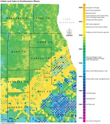
Northeastern Illinois was colonized by settlers from the United States beginning in the 1830s, following the survey and sale of Canal Lands within the canal corridor to private interests. The checkerboard pattern of sales in this diagonal yellow zone reflects the difference between early land purchases from the state Canal Commissioners (yellow and buff hues) and later acquisitions from the Federal Government (green and blue hues). Most of the remainder of the region was purchased by individuals during the 1840s, except for the Illinois portion of the Kankakee Marsh district in the southeast portion of the map which was not completely sold off until the 1850s and 60s. This pattern of differential timing in land sales strikingly demonstrates the impetus given to pioneer settlement by the Illinois & Michigan Canal.
The Electronic Encyclopedia of Chicago © 2005 Chicago Historical Society.
The Encyclopedia of Chicago © 2004 The Newberry Library. All Rights Reserved. Portions are copyrighted by other institutions and individuals. Additional information on copyright and permissions.
The Encyclopedia of Chicago © 2004 The Newberry Library. All Rights Reserved. Portions are copyrighted by other institutions and individuals. Additional information on copyright and permissions.