| Historical Source |
| A |
|
Aerial View of Circle Interchange Looking North, 1973
|
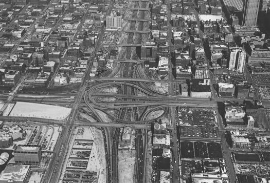
The Kennedy expressway runs north of the Circle Interchange and can be seen at the top of the photograph. The Ryan expressway reaches south at the bottom, the Eisenhower to the west, and Congress Parkway runs east from the Circle into city streets just south of the Loop. The University of Illinois's Chicago campus, once known as Circle Campus for its proximity to the traffic landmark, can be seen in the lower left corner of the photo.
The Electronic Encyclopedia of Chicago © 2005 Chicago Historical Society.
The Encyclopedia of Chicago © 2004 The Newberry Library. All Rights Reserved. Portions are copyrighted by other institutions and individuals. Additional information on copyright and permissions.
The Encyclopedia of Chicago © 2004 The Newberry Library. All Rights Reserved. Portions are copyrighted by other institutions and individuals. Additional information on copyright and permissions.