| Entries |
| C |
|
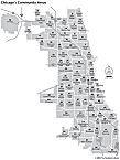
Community Areas
|
In the nineteenth century, the United States Bureau of the Census used the ward system to break down data within cities. This approach was unsuited for comparisons across time, because ward boundaries changed with each census cycle. The Federated Churches of New York pioneered the concept of the census tract in 1902; Chicago first used census tracts in 1910.
|
With two exceptions, there have been only minor changes in the community area map. Because the original map was designed after the great wave of annexations at the end of the nineteenth century, O'Hare (CA 76) was the only addition to the city that needed a separate designation. In 1980, Edgewater wrested a symbolic secession from Uptown, and was recognized as a distinct entity (CA 77).
Despite the uses scholars and planners have found for the concept of community areas, they do not necessarily represent how Chicagoans think about their city. Scholars have challenged the validity of the idea of “natural areas” since its inception. Prominent neighborhoods such as Pilsen and Back of the Yards are subsumed into the less familiar Lower West Side and New City. Many Roman Catholics are as comfortable with the names of parishes as of community areas. And the virtue of the community areas, their stability, means that they cannot accommodate transformations in the geography of Chicago, such as the mid-twentieth-century expressways that cut through once-coherent neighborhoods.
The Encyclopedia of Chicago © 2004 The Newberry Library. All Rights Reserved. Portions are copyrighted by other institutions and individuals. Additional information on copyright and permissions.