| Entries |
| M |
|
McKinley Park
|
 Community Area 59, 4 miles SW of the Loop. McKinley Park has been a working-class area throughout its long history. This tradition began around 1836 when
Irish
workers on the
Illinois & Michigan Canal
took squatter's rights to small tracts of land. By the 1840s, a few farmers had purchased and drained land and sent the Irish squatters packing. One of the first attempts at town building, “Canalport,” died stillborn, but Brighton was platted in 1840 and incorporated in 1851.
Community Area 59, 4 miles SW of the Loop. McKinley Park has been a working-class area throughout its long history. This tradition began around 1836 when
Irish
workers on the
Illinois & Michigan Canal
took squatter's rights to small tracts of land. By the 1840s, a few farmers had purchased and drained land and sent the Irish squatters packing. One of the first attempts at town building, “Canalport,” died stillborn, but Brighton was platted in 1840 and incorporated in 1851.
The completion of the Illinois & Michigan Canal in 1848 and the coming of the Chicago & Alton Railroad in 1857 spurred further subdivision of the area. The rails amplified the transportation advantages of the area, and during the Civil War industries located along the waterways and the railroad. The Union Rolling Mill was founded in the early 1860s along the south fork of the Chicago River and produced 50 tons of rails per day. Eventually, the firm became part of U.S. Steel.
|
The fire of 1871 displaced numerous industrial operations and many relocated to this area. Within five years after the fire 11 factories opened—most in iron and steel —along with 27 brickyards. During this same period, meatpacking operations just to the south moved into high gear. The result was the creation of the solid working-class community that still exists today.
The packinghouses fouled the environment and dumped wastes directly into the south fork of the Chicago River. Here the stream was such a hellish mess of decomposing material that it became known as “Bubbly Creek” because of the bubbles that constantly roiled its surface. The situation finally became so horrendous that the stream's upper reaches were filled in to rectify the problem.
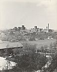
If industries created pollution, they also created many good industrial jobs and led to a period of unprecedented growth and prosperity. Irish, Germans, Swedes, English, and native-born Americans filled the industrial jobs of the 1870s. Even after 1900, when Poles and other Eastern Europeans came to the area, English prevailed as the street language, and the area was the most American of all settlements in the stockyard districts. Transportation had always been poor, but the 1880s and 1890s saw improvement and extension of the car lines on Archer Avenue and on 35th Street. As time passed, steel mills and brickyards closed and industries changed, replaced by new activities. The Central Manufacturing District was begun in 1905 on some 260 acres along the south fork. In the late 1990s it was still operating, Pepsi-Cola was opening a new bottling plant, and the Wrigley Company was still making chewing gum. Meanwhile, the Chicago Sun-Times was building a mammoth publishing and distribution plant west of Ashland along the Chicago River.
The beginning of the twentieth century led, after years of complaints by residents, to the creation of a park, which was named for President McKinley after his assassination. The 69-acre park now boasts a swimming pool and ice- skating rink. It is the area's showplace and led to the naming of the entire community.
After years of declining populations, during the 1990s the population grew from 13,297 to 15,962, with Mexicans joining the ethnic mix. Well-kept two- and four-flat buildings dominate the landscape, but new infill housing has begun to appear. Two stops on the CTA Orange Line rapid transit have boosted property values and spurred development of a new restaurant, shopping mall, and drugstore.
| McKinley Park (CA 59) | |||||
| Year |
Total
(and by category) |
Foreign Born | Native with foreign parentage | Males per 100 females | |
| 1930 | 22,032 | 23.0% | 50.4% | 107 | |
| 22,020 | White (99.9%) | ||||
| 3 | Negro (0.0%) | ||||
| 9 | Other (0.0%) | ||||
| 1960 | 16,908 | 10.0% | 32.2% | 98 | |
| 16,885 | White (99.9%) | ||||
| 23 | Other races (0.1%) | ||||
| 1990 | 13,297 | 18.9% | — | 96 | |
| 9,930 | White (74.7%) | ||||
| 10 | Black (0.1%) | ||||
| 53 | American Indian (0.4%) | ||||
| 342 | Asian/Pacific Islander (2.6%) | ||||
| 2,962 | Other race (22.3%) | ||||
| 5,255 | Hispanic Origin* (39.5%) | ||||
| 2000 | 15,962 | 37.9% | — | 100 | |
| 8,643 | White alone (54.1%) | ||||
| 172 | Black or African American alone (1.1%) | ||||
| 109 | American Indian and Alaska Native alone (0.7%) | ||||
| 1,228 | Asian alone (7.7%) | ||||
| 2 | Native Hawaiian and Other Pacific Islander alone (0.0%) | ||||
| 5,203 | Some other race alone (32.6%) | ||||
| 605 | Two or more races (3.8%) | ||||
| 9,819 | Hispanic or Latino* (61.5%) | ||||
The Encyclopedia of Chicago © 2004 The Newberry Library. All Rights Reserved. Portions are copyrighted by other institutions and individuals. Additional information on copyright and permissions.