Overview
The appellation Goose Island may have come from a small clay island, home to geese and other birds, located just to the north of the confluence of the north and south branches of the Chicago River. Goose Island became associated with a nearby Irish squatter settlement and as those squatters moved northward onto Goose Island, the name may have moved with them. In the late 1860s, Peoples Gas Light and Coke Company bought land just east of Goose Island and opened the Gas House. The flames from the plant led to the neighborhood nickname of "Little Hell," which was generally east of Goose Island although sometimes extended to parts of the Island.
The property on Goose Island was canal land, sold by the commissioners of the Illinois and Michigan Canal to help pay for the project. In 1832, Charles Taylor purchased 80 acres of land now known as Goose Island for $100. He sold it for more than $500 just a few months later. Speculators continued to buy and sell the land until the tract was sold in 1853 to the Chicago Land Company. William B. Ogden was a major stockholder in this company, and directed the dredging of a canal along the east side of the property. The dredged clay was used in area brickyards and also for landfill. The "Ogden" canal, then, formed Goose Island. In many accounts, Goose Island was referred to as Ogden Island.
Despite all of these industrial and residential developments, there remained large tracts of empty land at the turn of the century. North of Division, much of the land in the center of the island remained vacant. This land was used by residents for a variety of purposes. Alderman Thomas P. Keane, who grew up on Goose Island during the 1890s, remembered that "Every house had a garden and chickens, sometimes a goat . . . It was a little community where everybody knew everybody else. In the fall we all laid in wagon-loads of potatoes and cabbagees. The knife with which we cut up the cabbages for sauerkraut was passed from family to family." As in the 1850s, many residents still owned cows, fed from the slops of the local distillery.
No more than three families lived on Goose Island during the 1970s, and by 1985 only one house remained on the island. Goose Island had ended a second round of settlement, with most of the housing on its three residential streets destroyed. Despite the demise of worker housing, however, the area reemerged as a potential site for more affluent residents by the late 1980s. Just as developers eyed prime riverfront property closer to downtown, the empty lots on Goose Island began to attract interest and a healthy debate on the future of Goose Island ensued. One Near North residential developer commented: "Dirty industrial uses do not belong. As the city has changed over the years, it has become desirable that the heavy industry not be in the core of the city. It affects the quality of life for everybody. Although I don't think it should be legislated out of existence, it seems to me that over time it will be natural for it to move out." One longtime Goose Island resident disagreed, arguing for new industries to come to the island: "If it's a choice between industry or the new development [residential], I'd prefer the industry because it would be better for my business [restaurant and tavern.]" In May 1990, Mayor Daley backed the designation of Goose Island as a Planned Manufacturing District (PMD), which was supported by the local alderman. Daley commented that "the proposed district would help the industries on the island to expand and to retain jobs." By late 1997, virtually all the land in one of the resulting industrial parks had been filled.
Aerial of Goose Island, c.1970
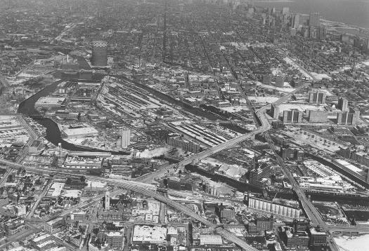
This aerial view of Goose Island shows the southern tip of the island (at Chicago Avenue) in the far right of the photograph and the northern end in the upper left at North Avenue. The North Branch of the Chicago River is the waterway to the left and the North Branch Channel is in the middle right. Division Street divided the island roughly in half.
See also: Chicago River; Near North Side; Goose Island
Historic Goose Island, 1930
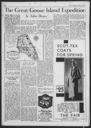
John Drury's Map of Goose Island was first published on March 26, 1930, in the Chicago Daily News. The map shows the location of Goose Island on Chicagos Near North Side, located between Chicago and North Avenues. Division Street runs across the middle of the island, which was formed after the dredging of the North Branch (Ogden) Canal. While this is a fanciful representation, the map does show the concentration of housing on North Branch, Cherry, and Hickory Streets south of Division Street. The foot of the island was home to shipyards, lumber yards, coal yards, and grain elevators.
See also: Near North Side; Goose Island; Chicago River
William B. Ogden, Creator of Goose Island, 1855
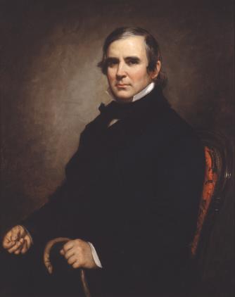
William B. Ogden arrived in Chicago in 1835 and for decades provided a crucial link with New York capital. Among the many enterprises of which he was a part: the Illinois and Michigan Canal; Galena and Chicago Union Railroad (the city's first); the City of Chicago (first mayor); Board of Sewerage; and the Union Pacific Railroad Company. Ogden saw the important connection between rail and water transportation and ran the terminus of the first railroad in Chicago right to the banks of the north branch. He worked to gain for the Chicago Canal and Dock Company (he was a major investor) control of property along the Chicago River and adjacent Lake Michigan, even hiring Abraham Lincoln to help him gain clear title to river and lakefront property.
See also: Economic Geography; Mayors; Politics; Transportation; Chicago River; Near North Side
The Encyclopedia of Chicago © 2004 The Newberry Library. All Rights Reserved. Portions are copyrighted by other institutions and individuals. Additional information on copyright and permissions.