Calumet Harbor
Twelve miles south of the Chicago River, several lakes and rivers abutted Lake Michigan, including Lake Calumet, Wolf Lake, the Little Calumet River, and the Grand Calumet River. As early as 1836, U.S. Army Engineers had identified this as an area that could be developed as a harbor. In 1869, the federal government appropriated funds to begin harbor improvements in the region. Improvements were made by the Calumet and Chicago Dredge and Dock Company which cut a channel from the Calumet River to Lake Michigan and dredged Lake Calumet.
Two decades later, the City of Chicago annexed a territory over two times its size, including the Calumet Region along the Indiana border. Harbor development shifted southward and by 1906 the Calumet Harbor outpaced traffic on the Chicago River. With deindustrialization in the late twentieth century, many of the industries which once lined the railroad and slips of the Calumet Region have closed down, and plans for redevelopment of the region included an ill-fated 1990 plan for an airport.
View Southwest from Calumet Harbor, 1874
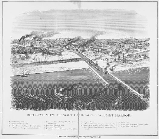
This birds-eye view shows ships entering and leaving the Calumet Harbor in 1874. Just a few years before, the federal government had made improvements to the Calumet River, including a lighthouse, breakwater, and dredging. Nearby railroads fostered both industry and trade, as the region emerged as an important transshipment point. The North Chicago Rolling Mills located its South Works just to the north of the mouth of the Calumet River, taking advantage of the excellent transportation facilities and relatively inexpensive lands.
See also: South Chicago; Calumet River; Calumet Region
South Chicago, 1874
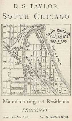
Real estate developers made speculative subdivisions of land around the Calumet River following the completion of federally-funded improvements in 1871.
D. S. Taylors subdivisions along the east side of the Calumet River shows the growing interest in the Calumet region by 1874. Slips and wharves along the Calumet River, as well as adjacent railroads, provided excellent transportation for industry and trade.
See also: South Chicago; East Side; Calumet River
Burnham Plan for Calumet Region, 1909

Daniel Burnham and Edward Bennett included discussion of the Calumet Harbor in their 1909 Chicago Plan. They called for docks at the mouth of the Calumet River for bulk freight steamers and noted that “access to be had without opening of bridges,” which was a major impediment to harbor traffic on the Chicago River.
See also: Planning Chicago; Calumet River
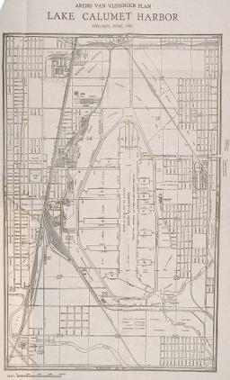
The 1920 Van Vlissengen Plan for the Calumet Region was adopted by the City of Chicago as the official plan for the region in 1921. This long-range development plan included both water and land transportation improvements. Plans for harbor improvements included both excavating more harbor area and filling in areas of Lake Calumet for use as additional industrial and terminal sites.
See also: Planning Chicago
The Encyclopedia of Chicago © 2004 The Newberry Library. All Rights Reserved. Portions are copyrighted by other institutions and individuals. Additional information on copyright and permissions.