| Historical Source |
| W |
|
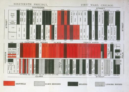
W. T. Stead Map, 1894
|
Stead's
If Christ Came to Chicago
opened with a foldout juxtaposing an image of Christ and the money changers with this map of the block bounded by Clark, Dearborn, Harrison, and Polk Streets in Chicago's First Ward. The map both illustrated many of the reform issues raised in the book and anticipated the use of mapping to present social information that informed the
Hull House Maps and Papers
and the Chicago School sociologists.
The Electronic Encyclopedia of Chicago © 2005 Chicago Historical Society.
The Encyclopedia of Chicago © 2004 The Newberry Library. All Rights Reserved. Portions are copyrighted by other institutions and individuals. Additional information on copyright and permissions.
The Encyclopedia of Chicago © 2004 The Newberry Library. All Rights Reserved. Portions are copyrighted by other institutions and individuals. Additional information on copyright and permissions.