By the 1830s, real estate speculation eclipsed the fur trade as the primary economic activity in the Chicago region. Land in the area entered the global market as a commodity, not just a resource. Speculators from Europe and the northeastern United States sent their representatives, who joined long-term residents and recent migrants in a scramble to select the most promising sections of commercial real estate. Federal and state politicians furthered the frenzy with government expenditures for improvements to the Chicago harbor and construction of a canal designed to facilitate travel between the Great Lakes and Mississippi River. Through such private and public investments, Chicago was emerging as a mercantile center--a transfer point through which Midwestern agricultural products reached Eastern markets, and Eastern manufactured goods reached Midwestern consumers.
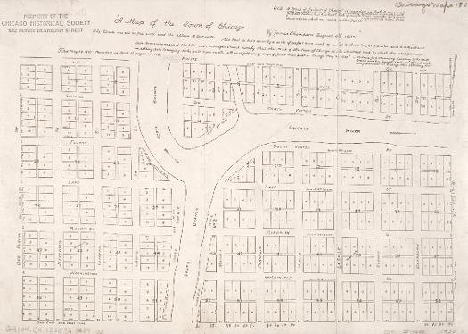
The Illinois and Michigan Canal Commissioners hired James Thompson, a surveyor from Kaskaskia in downstate Randolph County, to create Chicago's first plat (or map showing proposed lots) in 1830. He laid out the town with straight streets uniformly 66 feet wide (the length of a surveyor's chain) with alleys 16 feet wide bisecting each block.
See also: Contested Spaces; Mapping Chicago; Multicentered Chicago; Planning Chicago; Street Naming
Wright's Survey Map of Chicago, 1834
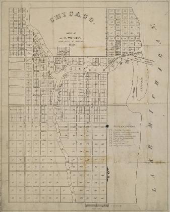
J. S. Wright's map of 1834 shows the city's familiar grid pattern, the cut in the sandbar that gave the Chicago River more direct access to Lake Michigan, Fort Dearborn just south and west of the cut (near the current Michigan Avenue Bridge), the North Side property of John Kinzie, the "Public Square" that became the site for a succession of city halls (including the present one), and South Water Street (now Wacker Drive). The grid pattern with its numbered lots allowed for clear determination of title--who held which plot of land--and thus facilitated long-distance real estate sales and speculation.
See also: Chicago River; Contested Spaces; Land Use; Mapping Chicago; Planning Chicago
Letter from Dixwell Lathrop to John Rockwell, 11 June 1835
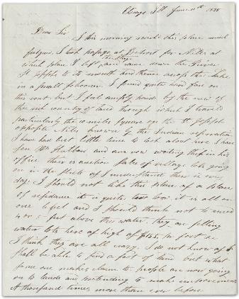
In Chicago, as in much of the Northwest Territory, the division of the land into lots for sale led to feverish land speculation. In 1835, John Rockwell commissioned Dixwell Lathrop to purchase land in the city as an investment. In this letter to Rockwell, Lathrop discusses the auctions of lots in Chicago. He is unimpressed by the town, and the price of $155 per square foot for water lots strikes him as "crazy." He announces that he will probably "bring your money home with me."
See also: Northwest Ordinance; Waterfront; Encountering the Prairie
Certificate of Sale of School Section Lands, 1836
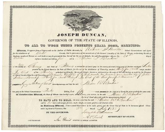
The deed issued to Madore Beaubien, son of fur trader Jean Baptiste Beaubien and Mahnobunoqua, a Grand River Ottawa woman, gave him title to "Lot number eight (8) of Block number one hundred and nineteen (119) of Section Sixteen Township Thirty five in North Range [Ten] East of the third principal meridian" in "Juliett." At the time this deed was issued, in 1836, Cook County extended further south than it does now to include Joliet, then known as Juliet or Juliett. Such legal documentation made global land sales possible by providing a level of assurance to long-distance buyers that their investments in the Chicago region were recognized by state authorities.
See also: Cook County; Fur Trade; Joliet, IL; Metis; County Boundaries (Map)
|
The Electronic Encyclopedia of Chicago © 2005 Chicago Historical Society.
The Encyclopedia of Chicago © 2004 The Newberry Library. All Rights Reserved. Portions are copyrighted by other institutions and individuals. Additional information on copyright and permissions. |