| MAPS : MAPS CREATED BY ENCYCLOPEDIA STAFF |
| C |
|
County Boundaries in the Chicago Area
|
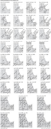
Counties are administrative subdivisions of their state, and, with few exceptions, state legislatures create them and make changes to their boundaries. In Illinois and Indiana, as in the rest of the United States, one of the important functions of counties has been the operation of the state judicial system. The county network usually blankets the entire state, including unpopulated areas, so that no place can be outside the jurisdiction of some sheriff or court. Additional responsibilities, many of which have grown in importance over time, have included probating wills, recording deeds and marriages, managing public health, conducting elections, and collecting taxes for the state, the minor civil divisions, and the special districts. Before the emergence of villages, cities, and similar units of local government in an area, counties provided the only local government. Virginia was first to organize county government for what became the Chicago metropolitan region. In December 1778, based upon the land grant in its 1609 colonial charter, Virginia created Illinois County to cover the region between the Mississippi and Ohio rivers. The federal government took control of that territory in 1784 and created the Northwest Territory to govern it. Subsequent authorities that were given jurisdiction over the Chicago area were Indiana Territory (1800) and state (1816) and Illinois Territory (1809) and state (1818). Before the 1830s county jurisdiction in the future Chicago area was uneven. Population initially flowed into Indiana and Illinois from the south; as a result, the network of counties in those states started at the Ohio River and spread northward in step with non-Indian settlement. Some counties (e.g., Pike and Putnam in Illinois) were extended far northward to cover all possible places, even though most of their territory had no settlers previously subject to the jurisdiction of the United States. Occasionally, there was no provision for county jurisdiction in the area. It was not until the 1830s, after a second wave of migrants heading westward from the Erie Canal (opened 1825) reached the southern end of Lake Michigan, that it became necessary to provide local county services. First was Cook County (1831), given responsibility for all of northeastern Illinois; second was Indiana's Porter County (1835), which brought United States-sanctioned government to northwestern Indiana where there had been no provision for such government since 1817. New counties were added as fast as new settlers poured into the area, and, by 1841, barely 10 years after the birth of Cook County, all but one of the counties of the Chicago area had reached their permanent configurations. The final boundary change (1853) shifted the southern line of Will County from the Kankakee River to the straight township and range lines of the federal Public Land Survey System. The arrangement of boundaries and areas does not always tell the full story of how judicial and administrative jurisdictions worked. Sometimes state legislatures created counties without putting them into operation. In order to provide a minimum of governmental services, such an unorganized county (or occasionally a noncounty area) was "attached" to a fully operational county. Only two of the Chicago area's counties were temporarily attached: McHenry was created in January 1836 and was unorganized and attached to Cook for the following 13 months. Lake County (Indiana), created in February 1836, was unorganized and attached to Porter for a year. Records of marriages, real-estate sales, and other events in those counties (including Lake, Illinois, then part of McHenry) will be found in the archives of their hosts at the time, not in their own courthouses, because at the time they had no facilities or officials.
The Electronic Encyclopedia of Chicago © 2005 Chicago Historical Society.
The Encyclopedia of Chicago © 2004 The Newberry Library. All Rights Reserved. Portions are copyrighted by other institutions and individuals. Additional information on copyright and permissions.
The Encyclopedia of Chicago © 2004 The Newberry Library. All Rights Reserved. Portions are copyrighted by other institutions and individuals. Additional information on copyright and permissions.