| MAPS : MAPS CREATED BY ENCYCLOPEDIA STAFF |
| R |
|
Railroads and Chicago's Loop, circa 1930
|
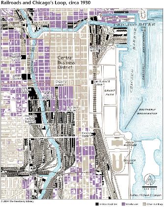
As the nation's single most important transportation hub, and as the key commercial pivot between the East and the great West, Chicago developed an extraordinary concentration of railroad terminals and related warehousing districts around its central business core. This map captures the pattern in 1930, when a great deal of urban manufacturing shared space with warehouse quarters (purple) adjacent to the railroad stations, yards, and riverfront and lakeside docks and elevators (black). The combination of these facilities created a complete collar five to eight blocks deep encircling the business district (dense brown), except on the eastern flank where Grant Park (white) was laid out between the Illinois Central tracks and Chicago Harbor.
The Electronic Encyclopedia of Chicago © 2005 Chicago Historical Society.
The Encyclopedia of Chicago © 2004 The Newberry Library. All Rights Reserved. Portions are copyrighted by other institutions and individuals. Additional information on copyright and permissions.
The Encyclopedia of Chicago © 2004 The Newberry Library. All Rights Reserved. Portions are copyrighted by other institutions and individuals. Additional information on copyright and permissions.