| Entries |
| I |
|
Irving Park
|
 Community Area 16, 7 miles NW of the Loop. Irving Park's past and present are tiedto preservation of its historic houses. Building finehouses was the conceptthat businessman Charles T. Race decided upon afterpurchasing acreage in 1869 from Major Noble, whose father had bought the land in 1833. Race had intended to become a gentleman farmer, but his land was so close to the Chicago & North Western
railroad,
he realized there would be more profit in beginning a settlement. After Race paid for a depot, the train line agreed to stop at the settlement, which was first called Irvington as a tribute to author Washington Irving, but was soon renamed Irving Park.
Community Area 16, 7 miles NW of the Loop. Irving Park's past and present are tiedto preservation of its historic houses. Building finehouses was the conceptthat businessman Charles T. Race decided upon afterpurchasing acreage in 1869 from Major Noble, whose father had bought the land in 1833. Race had intended to become a gentleman farmer, but his land was so close to the Chicago & North Western
railroad,
he realized there would be more profit in beginning a settlement. After Race paid for a depot, the train line agreed to stop at the settlement, which was first called Irvington as a tribute to author Washington Irving, but was soon renamed Irving Park.
Race built himself a three-story brick house with basement and “French roof.” Joined by associates, he organized the Irving Park Land Company, bought additional land, and subdivided it into lots. Advertisements promoted the area's easy access to downtown via hourly trains. Boasting an idyllic setting comparable to that of suburbs such as Evanston and Oak Park, the ad pointed to Irving Park’s “shady streets, fine schools, churches and stores,” and homes of varied designs. The Irving Park subdivision was followed by Grayland, Montrose, and Mayfair.
The commuter suburb attracted many wealthy residents who sought larger homes of between seven and ten rooms, and amenities that included closets and drinking water from artesian wells. Race and his associates garnered a 600 percent profit on the land. Other residents who were less affluent came to the area to remove their families from the dangers of the city. Rich or middle-class, the population of Irving Park was generally native-born, Protestant, and white-collar. They participated in community events and activities of a literary and musical nature. Both men and women were active in neighborhood organizations. The Irving Park Woman's Club formed in 1888 with an agenda of cultural and reform activities.
Suburban paradise was not without problems, however. In the 1880s heavy rains produced floods, and poor drainage turned unpaved streets to mud. In 1881 complaints were heard of raw sewage floating down Irving Park Road from the Cook County Poor House and Insane Asylum in Dunning.
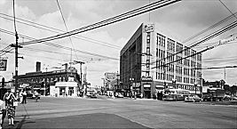
Although annexation of Irving Park into the city of Chicago as part of Jefferson Township occurred in 1889, in the 1890s streets were still unpaved and unlighted. As improvements were added, the main thoroughfare became a construction zone; streets were updated and public transportation was created. A residential boom between 1895 and 1914 added more than 5,000 new buildings, of which 1,200 were multifamily residences. New structures changed the housing composition of the area, leading to concerns about community standards.
|
A new emphasis on neighborhood unity and the preservation of area houses began in 1983 with the Old Irving Park Association (OIPA). The organization broke into two groups a year later, with the OIPA focusing on rehabilitating old houses, fund-raising for charity, helping needy residents, and sponsoring forums for political candidates.
The second association, the Old Irving Park Historical Society (OIPHS), began conducting an area house walk in 1985. They also worked on preservation. A number of structures have been cited as landmarks, including Carl Schurz High School and the Steven Race House. In the 1980s the Chicago Landmark Commission named 43 other buildings as potential landmarks.
Irving Park's population grew from 49,489 in 1980 to 58,643 in 2000. During those two decades the Hispanic population increased from 9 percent to 43 percent, and included immigrants from Central and South America along with larger numbers of Mexicans and Puerto Ricans. Filipinos and Indians predominated among Asians, who constituted 8 percent of the population in 2000.
| Irving Park (CA 16) | |||||
| Year |
Total
(and by category) |
Foreign Born | Native with foreign parentage | Males per 100 females | |
| 1930 | 66,783 | 23.9% | 43.1% | 98 | |
| 66,708 | White (99.9%) | ||||
| 37 | Negro (0.1%) | ||||
| 38 | Other (0.1%) | ||||
| 1960 | 58,298 | 14.7% | 32.3% | 91 | |
| 58,125 | White (99.7%) | ||||
| 20 | Negro (0.0%) | ||||
| 153 | Other races (0.3%) | ||||
| 1990 | 50,159 | 26.1% | — | 95 | |
| 39,801 | White (79.3%) | ||||
| 497 | Black (1.0%) | ||||
| 208 | American Indian (0.4%) | ||||
| 4,237 | Asian/Pacific Islander (8.4%) | ||||
| 5,416 | Other race (10.8%) | ||||
| 12,222 | Hispanic Origin* (24.4%) | ||||
| 2000 | 58,643 | 35.8% | — | 100 | |
| 37,216 | White alone (63.5%) | ||||
| 1,342 | Black or African American alone (2.3%) | ||||
| 307 | American Indian and Alaska Native alone (0.5%) | ||||
| 4,417 | Asian alone (7.5%) | ||||
| 39 | Native Hawaiian and Other Pacific Islander alone (0.1%) | ||||
| 12,092 | Some other race alone (20.6%) | ||||
| 3,230 | Two or more races (5.5%) | ||||
| 25,401 | Hispanic or Latino* (43.3%) | ||||
The Encyclopedia of Chicago © 2004 The Newberry Library. All Rights Reserved. Portions are copyrighted by other institutions and individuals. Additional information on copyright and permissions.