| MAPS : MAPS CREATED BY ENCYCLOPEDIA STAFF |
| G |
|
Growth of the Chicago Metropolitan Area
|
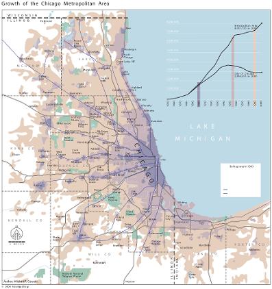
The growth of the built-up area of metropolitan Chicago can be summarized in three phases. Before 1900, streetcars and commuter railroad service conspired to create a fairly compact city together with small clusters of development around outlying railroad stations. Several outlying satellite cities, such as Joliet and Elgin, studded the hinterland. By 1955, the railroad suburbs had proliferated and matured, creating a massive star-shaped metropolitan geometry, while widespread automobile ownership had encouraged the extension of the continuously built-up zone around the urban core. After 1955, construction of the expressway system permitted a vast decentralization of population and activity which filled in many of the interstices between the railroad axes radiating from the central city, producing a more rounded overall geometry. By the end of the twentieth century, there was hardly a farmer's field to be seen within forty miles of the city center in any direction.
The Electronic Encyclopedia of Chicago © 2005 Chicago Historical Society.
The Encyclopedia of Chicago © 2004 The Newberry Library. All Rights Reserved. Portions are copyrighted by other institutions and individuals. Additional information on copyright and permissions.
The Encyclopedia of Chicago © 2004 The Newberry Library. All Rights Reserved. Portions are copyrighted by other institutions and individuals. Additional information on copyright and permissions.