| Historical Source |
| M |
|
Map of Cook and DuPage, and parts of Kane, Kendall, and Will Counties, 1851
|
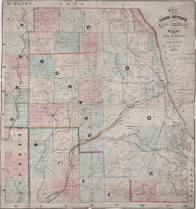
Water was a critical part of Chicago's regional development from its earliest days. Without railroads, expressways and individual cities or villages, this 1851 map is familiar and unfamiliar at the very same time. The township boundaries which divided the region into 36 square mile units create a grid still used in the present. They provide a means of orienting the modern day viewer, so we can see the underlying water landscape. Land agent James H. Rees paid careful attention to the rivers, creeks, lakes and marshes found in the region, illustrating the importance of water for American settlers pouring into the region in the 1840s and 1850s. Almost all of the platted towns seen on the map are along rivers or lakes. Early transportation relied on water and road connections, including routes linking Lake Michigan to the Mississippi River system. The largest public works project in evidence on the map is the Illinois and Michigan Canal connecting the south branch of the Chicago River Only the Galena and Chicago Railroad made its way westward from the City of Chicago, presaging the much more important role which railroads would play in Chicago's dramatic growth.
The Electronic Encyclopedia of Chicago © 2005 Chicago Historical Society.
The Encyclopedia of Chicago © 2004 The Newberry Library. All Rights Reserved. Portions are copyrighted by other institutions and individuals. Additional information on copyright and permissions.
The Encyclopedia of Chicago © 2004 The Newberry Library. All Rights Reserved. Portions are copyrighted by other institutions and individuals. Additional information on copyright and permissions.